Programme of research
This multidisciplinary scientific research project comprises the following study programmes:
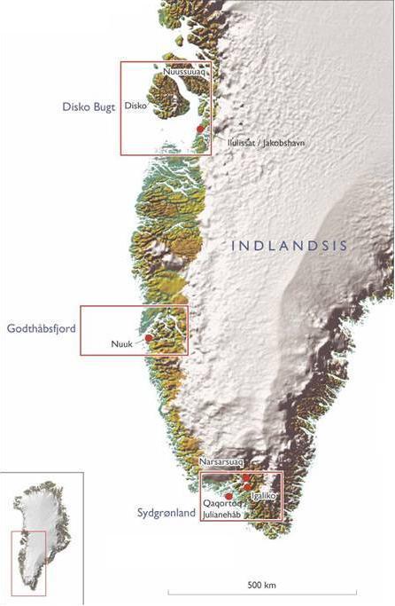
The marine geological programme is based on geophysical, sedimentological, micro-palaeontological and geochemical analyses and AMS C-14 and Pb-210 dating of sediment cores from the following three study areas: South Greenland, the Godthåb Fjord region, and the Disko Bay area (Appendix 1). Reflection seismic studies will be carried out in the three areas to document the subsurface geology and to locate suitable sedimentary basins for coring. The sediment cores will be extracted using a gravity corer (6 metre cores) and a piston corer (12 metre cores). In addition, box cores and seabed samples will be taken with a large grab at each site. Deep-tow side-scan sonar studies will be carried out in the valley systems off the large fjord systems, while ROV studies and vibro-coring will be undertaken in Igaliku Fjord to localise and subsequently date drowned beaches.
Geological studies on land will include sampling of sedimentary rocks in geological profiles, followed by geochemical and isotope geochemical studies in laboratories.
The marine biological study programme will comprise vertical measurements of salinity, temperature, chlorophyll, nutrients, carbon(DIC/alkalinity), the composition of the most important planktonic components, larvae, shrimps and fish. In a transect in the Godthåb Fjord region, measurements will be taken at the seabed of O2, carbon (DIC), the exchange of nutrients between the water phase and the seabed and of carbon burial. Conditions for the composition and spread of indicator species among seabed fauna will also be studied. Studies of the planktonic components will be undertaken using Bongo nets with 500 µm and 100 µm mesh, whereas the seabed fauna will be studied using grab samples and box cores.
Oceanographic studies will routinely encompass measurements of temperature, pressure, wind, precipitation, light, PAR & UVB; in addition, sea ice data off the west coast will be acquired from satellites. The oceanographic study programme also comprises a survey of horizontal and vertical temperatures, salinity and oxygen ratio using CTD, including water sampling for calibration of the sensors. Current conditions will also be measured using a ship-mounted ADCP. Surveying nutrient concentrations and other geochemical data will occur in the form of water samples using a rosette sampler coupled to the CTD.
Archaeological and cultural-historical studies will be made on land in the South Greenland area, in order to unravel the mutual relationships between Inuit and Norse settlements; preliminary excavations will be undertaken of selected sites. The study programme in the Disko Bay will encompass studies and surveys of the mutual relationship between Inuit ruins and sea level, and the location of settlements in relation to the movements of the glacier fronts. Historical sources will be included to throw light on the most recent history in south Greenland especially related to the migration from the east coast to the west coast of Greenland.
Schedule: The project is scheduled for 19 days, of which 14 days will be devoted to scientific work and 5 days to transits and port calls.
Appendix 1

 |
 Side 9 af 9 Side 9 af 9 |
|
|
|