Holocene fjord and shelf processes in West Greenland: a record of environmental and climatic change

Purpose

The aim of the project is to obtain new knowledge about changes in Greenland’s climate and recent geological history through studies of marine sedimentary sequences. The project focuses on studies of three coastal areas in West Greenland. Based on geological data from seabed cores and data from geophysical studies, Greenland’s climatic history and geological development since the last Ice Age will be examined and related to future climate scenarios and climate models. In this connection, the focus will be on the climatic development over the latest 4.500 years in order to elucidate the climatic and environmental changes that have influenced Greenland’s population and cultural history since the first Inuit migration to Greenland. In addition to the marine geological studies, a number of other research fields within the natural sciences and the humanities will form part of the project, including biology, oceanography, archaeology and history. It will thus be possible to study the interplay between some of the factors that have influenced climate development, settlement patterns and hydrological circulation in the west Greenland coastal areas since the end of the last glacial period.

Another important goal of the project is to strengthen and further develop research collaboration within the natural sciences and the humanities between Denmark and Greenland. In order to support research education and recruiting in Greenland young Greenland researchers will participate in the cruise and in the subsequent work.


Scientific background

During recent decades, the average temperature in the Arctic has risen more than twice as much as the temperature in the rest of the world, and widespread melting of sea ice has been observed. Climate models predict a pronounced rise in temperature in the Arctic area in the course of this century, with winters becoming shorter and warmer whilst precipitation increases at the same time as the snow and ice cover shrinks. This situation is the result of both known and as yet unproven processes and factors. However, the future climatic scenarios are not unique, as the geological history of the Earth shows both cyclic and chaotic variations in environmental and climatic conditions, which are today recorded in both recent/sub-recent and fossilised marine sediments.

The project will focus on marine geological studies of three areas along Greenland’s west coast: southwest Greenland in the Qaqortoq/Julianehåb area, the Godthåb Fjord region and the Disko Bay area (Appendix 1). Greenland’s climatic and geological history since the end of the Ice Age will be examined on the basis of geological data from sea-floor cores and data from geophysical studies. Studies of 3.8-billion-year-old marine sedimentary rocks will also be included in the project. The purpose of these studies is to compare and contrast these very old sediments with the recent/sub-recent marine sediments.


Holocene climatic variations and previous glaciation of the shelf

The primary scientific focus of the project is directed towards marine geological studies of three fjord and shelf areas in West Greenland. The goal is to establish an overall picture of the differences and similarities in the post-glacial development of these three areas, seen in a geological and climatic perspective. The project thus aims to reconstruct the changes in the circulation patterns in the Greenlandic fjords and shelf areas, and to relate these changes to Holocene climate changes. Special emphasis will be placed on reconstructing the freshwater melting of the Greenland Inland Ice, the extent of sea ice and the occurrence of icebergs off South and West Greenland, as well as the possible relationships and connections with the North Atlantic Thermohaline Circulation system, including the apparent counter-phase between the climatic conditions of South Greenland and Northwestern Europe.

The freshwater balance in polar areas is an important parameter that affects the global climate system, including the conditions in the Labrador Sea and the Davis Strait. Generally, an increase in freshwater inflow will favour the formation of sea ice in the Labrador Sea and lead to a reduction in deep-water convection, which, according to the climate models, may eventually lead to a reduction in the North Atlantic circulation and thus a colder climate in the North Atlantic region. Micropalaeontological studies of marine sediment cores will give a detailed picture of the late Holocene climate changes, including changes in the influence of the dominant North Atlantic Ocean currents. Special focus will be directed towards the West Greenland current system in the coastal areas of West Greenland, storm frequencies and variations in the quantity and occurrence of sea and fjord ice. Extensive valley systems are known to occur on the shelf off the larger fjord and are related to the melting of the Greenland Inland Ice. Using side-scanning sonar studies, selected parts of these valley systems will be surveyed and their origins investigated. The Ilulissat/Jakobshavn Glacier flows into the Disko Bay area, where the outflow of freshwater forms a freshwater plume, while the sea ice formation in winter results in the formation of salt water with high density. During the advances and retreats of the glacier front, the plume has changed position, and these changes will be surveyed. Furthermore, the Egedesminde Trench in the Disko Bay and the large submarine sediment fan flanking the shelf will be studied with a view to determining the mode of formation and the age of these geological structures.

The shelf off the west coast of Greenland displays features indicating that large numbers of icebergs have ground their way across the seabed during times of lowered sea level. The direction and extent of these plough marks will be surveyed using deep-tow sidescan sonar equipment. Studies will be carried out in the Disko Bay area in particular, where large icebergs from the Ilulissat Glacier are believed to have left deep tracks in the seabed; the direction and size of the tracks testify to changes in the direction and strength of the ice flows. Geophysical investigations will also provide information on features such as drowned coastlines, lateral moraines, turbidites and changes in the sea level.

In connection with sampling the seabed using a grab sampler off Ilulissat Icefjord, the sediments’ contents of Ice Rafted Detritus (IRD) will be examined. As this material can only originate from ice that has gathered its load from the bedrock, an analysis of the IRD will provide data on the nature of these rocks, which are presently covered by the ice stream.

A distinct Mid-Holocene reflector has previously been observed in the sediment succession off Christianshåb. This reflector can be reached using a piston corer, which will make it possible to date and examine the mode of formation of this distinctive surface.


Glaciology

In recent years, there has been particular focus on changes in the dynamics of ice flows, glaciers and ice shelves. These changes are to a large degree the result of the pronounced melting, retreat and break-up of the ice, a pattern that has been replicated globally within a range of glaciers and icecaps. Pronounced changes in the dynamics of the Inland Ice and the glaciers in Greenland have also been registered, as illustrated by the Ilulissat Glacier. The flow rate of this glacier has almost doubled (to 13 km/year) since 1997. In this connection, the Ilulissat Icefjord and Disko Bay are unique areas of study, as the advances and retreats of the glacier front have been documented in detail since 1850. These glacier front changes are reflected in the distribution of Inuit settlements along the fjord. New model studies show that a possible response by Greenland’s ice cap to continued global warming will be an acceleration of the glaciers’ speed, displacement of the glaciers’ front on to the shelf and an increase in the production of icebergs. To be able to predict the response of the ice cap to global warming, it is necessary to understand the factors that control these movements. It has been shown that changes in the dynamics of a glacier front can quickly propagate upstream and have a pronounced effect on the drawdown of ice, which occurs from the ice cap to the oceans. This increase in the outflow of glacial ice to the oceans influences both the global sea level and the flux of freshwater to the oceans. At Ilulissat, however, it has been shown, that a temperature increase in the area at the start of the 1900s did not influence the location of the glacier front. It is therefore unclear whether this ‘insensitivity’ was the result of a delay in the climate/ice/ocean system response to the change in temperature, or if the present sudden change is due to completely different factors. To determine possible factors affecting the stability of a glacier, the advances and retreats of the glacier over a longer period of time must be surveyed and put into the context of previous climatic variations, as reflected in sediment cores.


Climate changes, cultural patterns and settlements

Over a short time span, large but long-term climate changes are not immediately seen to influence biological ecosystems and cultures. On the other hand, pronounced short-term climate changes can significantly influence both biological and social systems – especially in Arctic regions, where conditions for life are marginal. Since the first immigration, people in Greenland have lived in coastal and fjord areas – and through history they have been affected by both small and large changes in the marine climate and environment.

Natural science and humanities research is combined in the project in order to relate information about changes in Greenland’s cultural history to data concerning climate and environmental changes. The studies will focus on the various waves of Inuit  immigration, which have moved along the Greenland coast in the course of the latest 4,500 years, in an attempt to determine whether the different cultures arose and disappeared synchronously with changes in climatic and environmental conditions, or if other factors were involved.

The Norse period, when descendants of European Vikings lived in Greenland from about 1000 to 1500 AD, will also be the subject of a combined natural science-archaeological study. The Norse settled during the warm period in Greenland as farmers in Southwest Greenland and in the Godthåb Fjord region. The settlement in the Godthåb Fjord region was abandoned after 300 years, while the settlement in South Greenland was depopulated by the end of the 1500s. Preliminary studies indicate that the extinction of the Norse settlements can to some extent be connected with climate changes. As part of further investigation into the cause of the disappearance of the Norse, the marine geological studies are supplemented by land-based archaeological observations. These investigations will provide information on the Norse’ social strategies in relation to the changes in climate and environment. In the Disko Bay area, the combined geological and archaeological studies will more closely examine the relationship between the Inuit settlement patterns, the marked changes in sea level and the advances and retreats of the glaciers. In south Greenland, historical documents will be used to investigate the migration of people from the east coast to the west coast of Greenland about 100 years ago and eventually relate this pattern to changes in the social structure and external factors such as climate change.


Marine climatic framework

In association with geological sampling, it is also important to collect physical and chemical oceanographic information with a view to surveying the marine climate conditions under which present sedimentation occurs. This will form the basis for establishing a relationship between present conditions and the information, contained in sediment cores, about climatic conditions of previous ages. 

The marine climate in West Greenland is today dominated by atmospheric changes and the inflow of Arctic water via the East Greenland Current and Atlantic water via the Irminger Current. Thus currents, salinity and temperature in West Greenland depend to a large extent on the ocean circulation in the North Atlantic and its variability. As the North Atlantic Oscillation (NAO) has a large influence on both the atmospheric conditions in Greenland and the ocean circulation in the North Atlantic, and thus on the intensity of the inflow of Polar and Irminger water to West Greenland waters, there is a close correlation between NAO and West Greenland’s marine climate. The observed counter-phase in air temperature between West Greenland and Northern Europe is well known today and a large part of it is believed to be related to NAO. In the course of the warming that has occurred over large parts of the northern hemisphere in the last decades, however, a smaller cooling in South Greenland and Northeast Canada has been observed; this is too pronounced to be explained by a positive NAO phase alone. Through studies of sediment cores, NAO’s phase/counter-phase through time will be examined.

Establishing a relationship between information from sediment cores and the marine climate will therefore contribute to a survey of the change in the West Greenland marine climate over time and indirectly show NAO’s variability in previous periods. This will contribute to an increased understanding of Greenland’s climate and its effects on marine ecology.


West Greenland’s marine biological system

The marine ecosystems of West Greenland are today very productive and form the basis for a large fishing industry. An understanding of the environmental conditions off Greenland’s west coast builds on an understanding of the interplay and relationship between the cold East Greenland Current and the warmer Irminger Current. Oceanographic studies of these currents will significantly improve the understanding of this interplay.

Sea ice also plays an important role. Observations of sea ice have shown a marked reduction in both areal extent and thickness in the Arctic Ocean and along Greenland’s east coast. The extent of sea ice off Greenland’s west coast has also been reduced, although to a lesser extent. Regional climate calculations predict a continued reduction in sea ice cover during this century. In particular, changes in the distribution of sea ice and the contribution of freshwater from land could have a pronounced effect on biological production and transport of carbon within the marine system. Research results from Greenlandic waters have shown that primary production rises as a consequence of a reduction in sea ice cover and consequently increased light for photosynthesis, which has a major influence on all trophic levels. The results will, in the future, contribute to understanding of how the ongoing climate changes affect the distribution, composition and production of marine plants and animals in the Arctic region. These data will be compared with data from sediment cores in order to examine the development over time. Should the climate and ocean currents change, this can have great consequences for the West Greenland marine ecosystems and thus for the Greenlandic society.

On the basis of detailed studies of a transect from the bottom of Godthåb Fjord to beyond the edge of the shelf, marine biological studies will increase the understanding of the relationship between the biological conditions (e.g. primary production, grazing, decomposition, food-chain structure and species composition) and physical parameters (e.g. climate, snow and sea ice conditions, freshwater inflow, salinity, temperature). In addition, biological studies of the plankton content of the water column will be undertaken and compared with the geological data.


Earliest life and the carbon cycle

After it was formed 4.6 billion years ago, the Earth was subjected to a heavy bombardment by meteorites, which decreased after about 700 million years. This allowed the Earth’s crust to stabilise, and just 100 million years later life in the form of plankton had colonised the oceans. Traces of these planktonic organisms are found today as biogenic carbon in the world’s oldest rocks at Isua in the Godthåb Fjord region. The exciting aspect of these early organisms is that they might have contributed to reducing the quantity of the greenhouse gas CO2in the atmosphere in an early phase of the Earth’s geological development, thus helping reduce the Earth’s temperature at a time when radiation from the Sun underwent a pronounced increase. It has not yet been determined whether this is the case, but one or more factors must have prevented total evaporation of the early seas and consequent desiccation of the planet. The project will focus on the 3.8-billion-year-old marine metasediments from Isua; geochemical and geological studies will focus on the incipient interplay between the Earth and its living organisms. An international research team will look for signs of microbial decomposition of the seafloor some 3.8 billion years ago. The project will similarly try to determine the origin of water on Earth, and how the water cycle functioned in the early history of the Earth.

In order to establish a modern analogy to these early sediments found at Isua, Holocene carbon cycles in the West Greenland fjord systems will be studied. At a depth of several metres below the seabed, large quantities of methane gas are produced as a result of the decomposition of organic matter. Methane, like carbon dioxide, is both an important component of the carbon cycle and an important greenhouse gas. There is concern about increased methane release from Arctic areas, since this may be linked to, and result in, increased rates of global warming. In this context, the decomposition of organic material and methane release from the seabed will be examined in the most recent parts of the sediment cores in order to increase our understanding of the carbon cycle in the Arctic marine environment, including the link to present as well as past climate change.


Programme of research

This multidisciplinary scientific research project comprises the following study programmes:

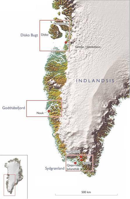
The marine geological programme is based on geophysical, sedimentological, micro-palaeontological and geochemical analyses and AMS C-14 and Pb-210 dating of sediment cores from the following three study areas: South Greenland, the Godthåb Fjord region, and the Disko Bay area (Appendix 1). Reflection seismic studies will be carried out in the three areas to document the subsurface geology and to locate suitable sedimentary basins for coring. The sediment cores will be extracted using a gravity corer (6 metre cores) and a piston corer (12 metre cores). In addition, box cores and seabed samples will be taken with a large grab at each site. Deep-tow side-scan sonar studies will be carried out in the valley systems off the large fjord systems, while ROV studies and vibro-coring will be undertaken in Igaliku Fjord to localise and subsequently date drowned beaches.

Geological studies on land will include sampling of sedimentary rocks in geological profiles, followed by geochemical and isotope geochemical studies in laboratories.

The marine biological study programme will comprise vertical measurements of salinity, temperature, chlorophyll, nutrients, carbon(DIC/alkalinity), the composition of the most important planktonic components, larvae, shrimps and fish. In a transect in the Godthåb Fjord region, measurements will be taken at the seabed of O2, carbon (DIC), the exchange of nutrients between the water phase and the seabed and of carbon burial. Conditions for the composition and spread of indicator species among seabed fauna will also be studied. Studies of the planktonic components will be undertaken using Bongo nets with 500 µm and 100 µm mesh, whereas the seabed fauna will be studied using grab samples and box cores.

Oceanographic studies will routinely encompass measurements of temperature, pressure, wind, precipitation, light, PAR & UVB; in addition, sea ice data off the west coast will be acquired from satellites. The oceanographic study programme also comprises a survey of horizontal and vertical temperatures, salinity and oxygen ratio using CTD, including water sampling for calibration of the sensors. Current conditions will also be measured using a ship-mounted ADCP. Surveying nutrient concentrations and other geochemical data will occur in the form of water samples using a rosette sampler coupled to the CTD.

Archaeological and cultural-historical studies will be made on land in the South Greenland area, in order to unravel the mutual relationships between Inuit and Norse settlements; preliminary excavations will be undertaken of selected sites. The study programme in the Disko Bay will encompass studies and surveys of the mutual relationship between Inuit ruins and sea level, and the location of settlements in relation to the movements of the glacier fronts. Historical sources will be included to throw light on the most recent history in south Greenland especially related to the migration from the east coast to the west coast of Greenland.

Schedule: The project is scheduled for 19 days, of which 14 days will be devoted to scientific work and 5 days to transits and port calls.


Appendix 1
Greenland